

Instrumented moorings
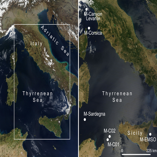
The Institute of Marine Sciences (ISMAR) of the National Research Council manages a network of instrumented moorings throughout the Mediterranean Sea. These monitoring sites are located in key areas, including the Sicilian Channel, Corsica Channel, Sardinia Channel, Ionian Sea, and Tyrrhenian Sea.
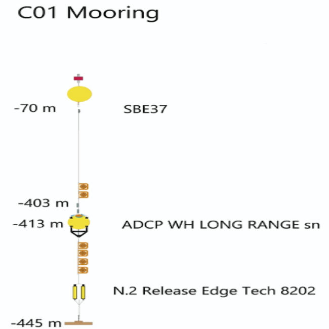
Sicily Channel 1 (C01)
Location: 37.380° N, 11.591° E
WMO code: 6101021
Sicily Channel 1 (C01) is a deep submarine multidisciplinary station managed by ISMAR, positioned between the coasts of Sicily and Tunisia at a depth of 450 meters, near the western sill of the Sicily Strait. Operational since 1993, this station monitors long-term surface and intermediate circulation, as well as water exchanges between the eastern and western Mediterranean basins.
Originally equipped with traditional current meters, C01 now features an ADCP for current profiling across the water column and high-precision CTD probes at the seabed for continuous measurements of temperature and salinity. C01 is part of the CIESM Hydrochanges project and has contributed data to the JERICO/JERICO-NEXT transnational access projects (EU FP7 G.A. n. 262584 and EU H2020 G.A. n. 654410).
Through the PAC project’s structural funds, C01 was upgraded with multiparametric sensors to measure temperature, salinity, oxygen, turbidity, and pCO₂. A conversion to an inductive mooring system has been tested to enable real-time data transmission
Publications:
Astraldi, M., Gasparini, G.P., Sparnocchia, S., Moretti, M. and Sansone, E.: The characteristics of the water masses and the water transport in the Sicily Strait at long time scales. In Dynamics of Mediterranean Straits and Channels, F. Briand (ed.), Bulletin del l’Institut Océanographique, Monaco, no spécial 17, CIESM Science Series no 2, 95-115, 1996.
Gasparini, G.P., Smeed, D.A., Alderson, S., Sparnocchia, S., Vetrano, A. and Mazzola, S.: Tidal and subtidal currents in the Strait of Sicily, J. Geophys. Res., 109, C02011, doi:10.1029/2003JC002011, 2004.
Gasparini, G.P., Schroeder, K. and Sparnocchia, S.: Straits and Channels as key regions of an integrated marine observatory of the Mediterranean: our experience on their long-term monitoring. In Towards an integrated system of Mediterranean marine observatories, F. Briand (Ed.), CIESM Workshop Monographs, No 34, 75-79, 2008.
Schroeder, K. et al.: Long-term monitoring programme of the hydrological variability in the Mediterranean Sea: a first overview of the HYDROCHANGES network. Ocean Sci., 9, 301–324, 2013, doi:10.5194/os-9-301-2013.
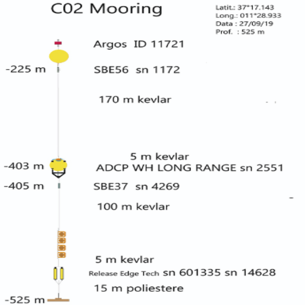
Sicily Channel 2 (C02)
Location: 37.285° N, 11.5° E
WMO code: 6101022
Sicily Channel 2 (C02) is located about 20 nautical miles west of C01, near the western sill of the Sicily Strait, at a depth of 530 meters. Similar to C01, C02 is dedicated to long-term monitoring of surface and intermediate water circulation and exchange between the eastern and western Mediterranean. It has been operational since 1993, initially with current meters and now featuring an ADCP for current profiling across the water column and high-precision CTD probes at the seabed.
C02 is also part of the CIESM Hydrochanges project and contributes to the JERICO/JERICO-NEXT transnational access projects (EU FP7 G.A. n. 262584 and EU H2020 G.A. n. 654410).
Publications:
Astraldi, M., Gasparini, G.P., Sparnocchia, S., Moretti, M. and Sansone, E.: The characteristics of the water masses and the water transport in the Sicily Strait at long time scales. In Dynamics of Mediterranean Straits and Channels, F. Briand (ed.), Bulletin del l’Institut Océanographique, Monaco, no spécial 17, CIESM Science Series no 2, 95-115, 1996.
Gasparini, G.P., Smeed, D.A., Alderson, S., Sparnocchia, S., Vetrano, A. and Mazzola, S.: Tidal and subtidal currents in the Strait of Sicily, J. Geophys. Res., 109, C02011, doi:10.1029/2003JC002011, 2004.
Gasparini, G.P., Schroeder, K. and Sparnocchia, S.: Straits and Channels as key regions of an integrated marine observatory of the Mediterranean: our experience on their long-term monitoring. In Towards an integrated system of Mediterranean marine observatories, F. Briand (Ed.), CIESM Workshop Monographs, No 34, 75-79, 2008.
Schroeder, K. et al.: Long-term monitoring programme of the hydrological variability in the Mediterranean Sea: a first overview of the HYDROCHANGES network. Ocean Sci., 9, 301–324, 2013, doi:10.5194/os-9-301-2013.
Corsica Channel
Location: 43.025° N, 9.6833° E
WMO code: 6101020
The Corsica Channel station is an underwater monitoring site managed by ISMAR, located between the island of Capraia and Corsica at a depth of approximately 450 meters. Operational since 1985, this station continuously records sea currents and thermohaline properties at specific depths to monitor circulation and water exchanges between the Tyrrhenian and Ligurian Seas.
As part of the CIESM Hydrochanges program and the JERICO transnational access program (EU FP7 G.A. No. 262584), the station has contributed to long-term monitoring projects. Since 2013, it has also measured pCO₂ at 400 meters depth under the PERSEUS project (EU FP7 G.A. No. 287600). Funded nationally through the RITMARE and SSD Fisheries projects, the station’s current meter chain is equipped with a Profiling Buoy System for real-time data transmission via Iridium (SBD).
This Profiling Buoy System includes:
- A winch and profiling buoy with multi-parameter probes (temperature, salinity, oxygen, chlorophyll).
- An Iridium antenna for satellite communication, acoustic communication, and data logging.
- The capability for remote data adjustments via ship-based or satellite commands.
Publications:
Astraldi, M. and Manzella, G. M. R.: Some observations on current measurements on the Eastern Ligurian Shelf, Mediterranean Sea, Cont. Shelf Res., 2, 183–193, 1983.
Astraldi, M., Gasparini, G. P., Manzella, G. M. R. and Hopkins, T.: Temporal variability of currents in the eastern Ligurian Sea, J. Geophys. Res., 95(C2), 1515–1522, 1990.
Astraldi, M. and Gasparini, G.P.: The seasonal characteristics of the circulation in the north Mediterranean basin and their relationship with the atmospheric-climatic conditions, J. Geophys. Res., 97 (C6), 9531-9540, 1992.
Astraldi, M., Gasparini, G.P. and Sparnocchia, S.: The Seasonal and Interannual Variability in the Ligurian-Povencal Basin. In Seasonal and Interannual Variability of the Western Mediterranean Sea, P.E. La Violette (Ed.), Coastal and Estuarine Studies vol. 46, AGU, 93-113, 1994.
EURO MODEL Group: Progress from 1989 to 1992 in understanding the circulation of the Western Mediterranean sea. Oceanologica Acta, 18(2), 255-271, 1995.
Vignudelli, S., Gasparini, GP., Astraldi, M. and Schiano, M.E.: A possible influence of the North Atlantic Oscillation on the circulation of the Western Mediterranean Sea, Geophys. Res. Letters, 26(5), 623-626,1999.
Vignudelli, S., Cipollini, P., Astraldi, M., Gasparini, G.P. and Manzella, G.: Integrated use of altimeter and in situ data for understanding the water exchanges between the Tyrrhenian and Ligurian Seas, J. Geophys. Res., 105(C8), 19649–19663, 2000.
Gasparini, G.P., Schroeder, K. and Sparnocchia, S.: Straits and Channels as key regions of an integrated marine observatory of the Mediterranean: our experience on their long-term monitoring. In Towards an integrated system of Mediterranean marine observatories, F. Briand (Ed.), CIESM Workshop Monographs, No 34, 75-79, 2008.
Schroeder, K. et al.: Long-term monitoring programme of the hydrological variability in the Mediterranean Sea: a first overview of the HYDROCHANGES network. Ocean Sci., 9, 301–324, 2013, doi:10.5194/os-9-301-2013.
Aracri, S., Borghini, M., Canesso, D., Chiggiato, J., Durante, S., Schroeder, K., Sparnocchia, S., Vetrano, A., Honda, T., Kitawaza, Y., Kawahara, H. and Nakamura, T.: Trials of an autonomous profiling buoy system, J. Oper. Oceanogr., Journal of Operational Oceanography, 9:sup1, 176-184, 2016.
EMSO SN1
Location: 37.5400433° N, 15.397313333° E
Codice WMO: 6202000
EMSO SN1 is a deep-sea mooring co-managed with INGV and located at the SN1 node of the European Multidisciplinary Seafloor Observatory (EMSO) infrastructure, 25 km off the coast of Catania, Sicily. Positioned at a depth of about 2010 meters, EMSO SN1 complements the SN1 infrastructure by monitoring critical parameters in the water column.
Since its deployment on March 18, 2015, at coordinates 37°32.4026′ N, 15°23.8388′ E, this inductive mooring has conducted continuous measurements at multiple depths:
- Temperature, salinity, dissolved oxygen, and turbidity at 380 m, 890 m, 1390 m, and 1890 m.
- Partial pressure of CO₂ and bottom pressure at 1990 m.
- Current profiles at depths of 0-380 m, 790-890 m, and 1290-1390 m.
Data are logged by the CommTech LISC control system installed at the mooring’s base. Currently, the system operates in recording mode, with plans to enable real-time data transmission via acoustic communication with the SN1 junction box using fiber optics.
A Profiling System was added on March 16, 2016, to monitor water properties from approximately 150 m depth to the surface. This system includes:
- A winch and profiling buoy with multi-parameter probes (temperature, salinity, oxygen, turbidity, fluorescence).
- Acoustic communication, data logging, and Iridium satellite data transmission.
- A pre-set ascent schedule of once every two days.
The infrastructure was developed with funding from the PAC program (“Plan of Action and Cohesion for Convergence Regions”), under the EMSO-MedIT project (PAC01_00044), financed by Italy’s Ministry of University and Research (MIUR), Notice D.D. No. 274 of 15/02/2013.
Publications:
S. Sparnocchia, M. Borghini, S. Durante, V. Meccia, A. Giordano and G. Biasini, “From the seafloor to the sea surface: A technical solution for the cabled EMSO-SN1 observatory in the Western Ionian Sea,” OCEANS 2015 – Genova, Genova, Italy, 2015, pp. 1-5, doi: 10.1109/OCEANS-Genova.2015.7271527.
Sardinia Channel
Location: 38.3341° N, 9.33265° E
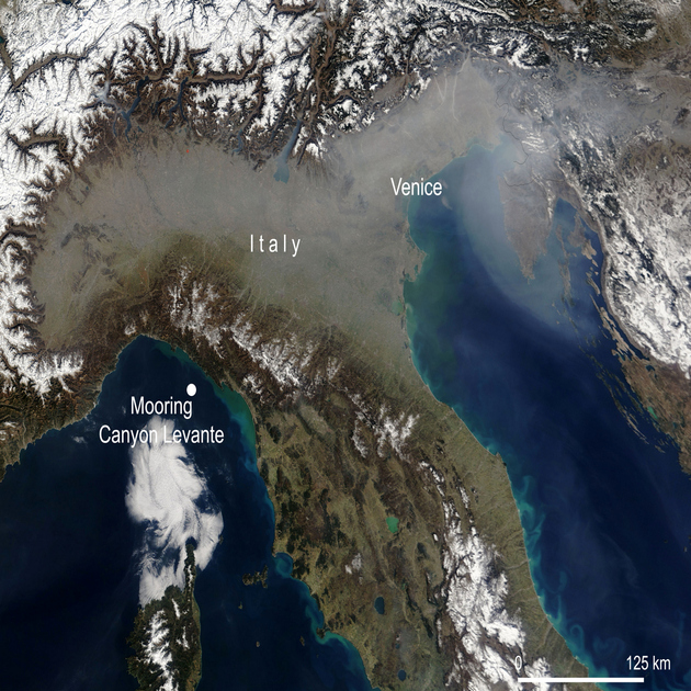
Eastern Canyon
Location: 44.0907167° N, 9.498333333° E
The Eastern Canyon station is a mooring site positioned on a 600-meter seabed near the Cinque Terre Marine Protected Area. Established in September 2019, this station is dedicated to monitoring essential marine parameters, including currents, temperature, and salinity at three distinct depths along the water column. The station is also equipped with sediment traps for comprehensive sediment analysis.
Since October 2022, Eastern Canyon has been outfitted with specialized instrumentation to study plastic degradation processes in deep-sea environments, contributing to research on marine pollution and ecosystem health in the Mediterranean.