
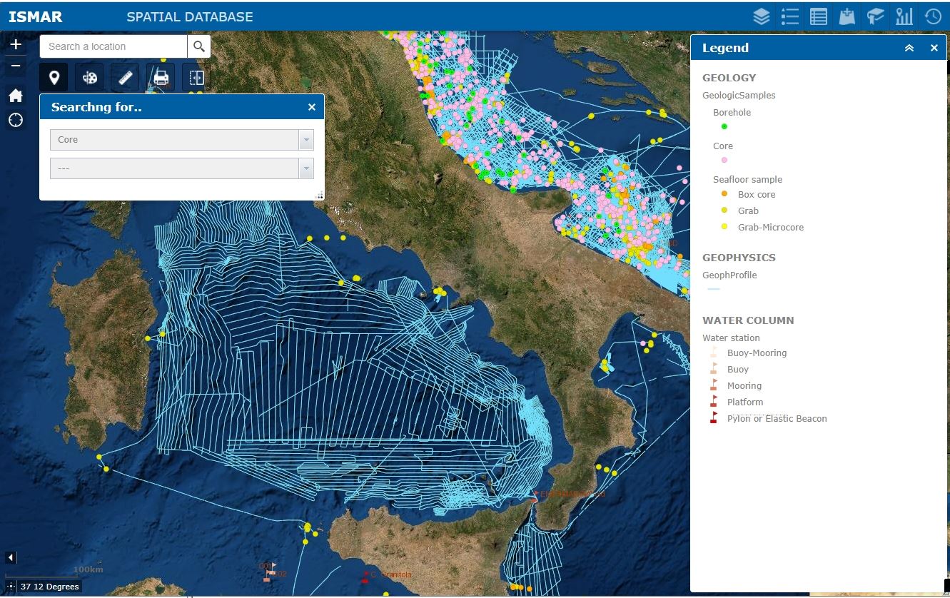
ISMAR WebGIS
The Geoportal for marine spatial data aspires to integrate all the data collected by ISMAR and ISP in the last decades across the glode. The user can navigate the map and query the spatial objects including survey areas, seismic profiles, seafloor and water column samples. Futhermore, some research products are available for consultation, such as the carthography.
The geoportal is a cartographic viewer for the consultation and visualization of GIS data via web. Compared to the simple GIS, it allows users to store, view, consult and manage online all spatial data (associated with geographic coordinates) through a map and the related non-spatial information through tables.
The Geoportal is part of a Spatial Data Infrastructure (SDI) developed over the years at the CNR-ISMAR based in Bologna, in the framework of various national and international research projects and for operational requests. The other components of the SDI are: a relational spatial database inspired by the data models proposed by the INSPIRE Directive; a metadata catalogue that makes the data present in the Geoportal searchable and possibly accessible/reusable; and a cloud storage for data flow management.
Advantages:
- Centralized information management;
- Accesibility to information layers available through the metadata catalogue;
- Download of cartographic data, if required;
- Immediate distribution via OGC services (WMS, WFS, WCS);
- Widespread diffusion;
- Interaction in real time and without the need of specific software;
- Management of different types of users.
To get information, please contact:
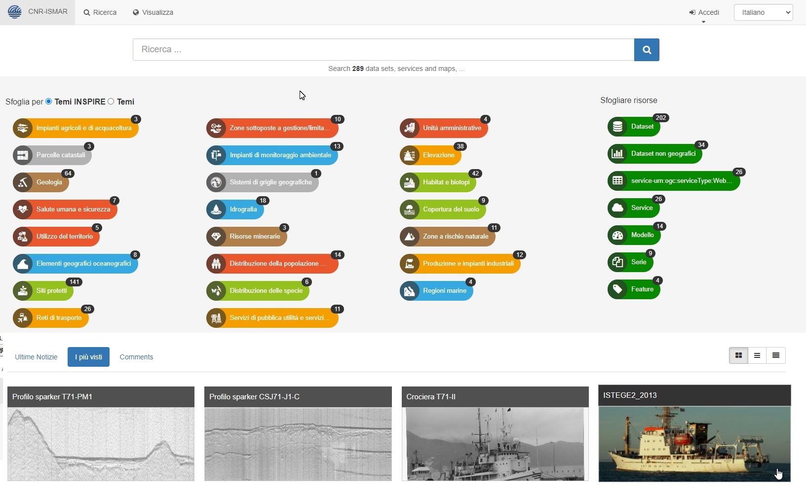
GEONetwork
The Geonetwork metadata catalogue collects the digital objects produced by ISMAR and ISP in the last decades. It describes geospatial resources, web services, maps and also non-spatial datasets with the aim to share information about:
- Presence of data and products;
- Data policy;
- Access and constraints;
- Data history;
- Points of contact.
A Metadata (from the Greek meta “beyond, after” and from the Latin datum “information”) is the information that describes a digital resource. A Catalog is a discovery service powered by the metadata, which constitutes a real “catalog” of data and services managed by a Spatial Data Infrastructure (SDI). It allows users to search for information in OGC – CSW (Catalog Web Service) format. Once the data or service of interest has been identified, its metadata can be consulted and downloaded. Where required by the dissemination policies adopted by the owners, the user can download the data or request the access.
This Metadata Catalogue is implemented using the open source software GeoNetwork for the management of spatially referenced resources. The Catalogue is part of a Spatial Data Infrastructure (SDI) developed over the years at the CNR-ISMAR based in Bologna, in the framework of various national and international research projects and for operational requests. The other components of the SDI are: a relational spatial database inspired by the data models proposed by the INSPIRE Directive; a Geoportal that integrates and makes accessible the digital resources described in the catalogue; and a cloud storage for data flow management.
Advantages:
- Find & Get information;
- Describe & Publish;
- Resources management.
To get an account, please contact:
CIGNo – Venice
CIGnO is the interoperable collaboration geographical platform of Institute ISMAR for sharing geospatial data and maps. It started in 2010 with CORILA and Venice City Council to work together with the Laguna Atlas project.
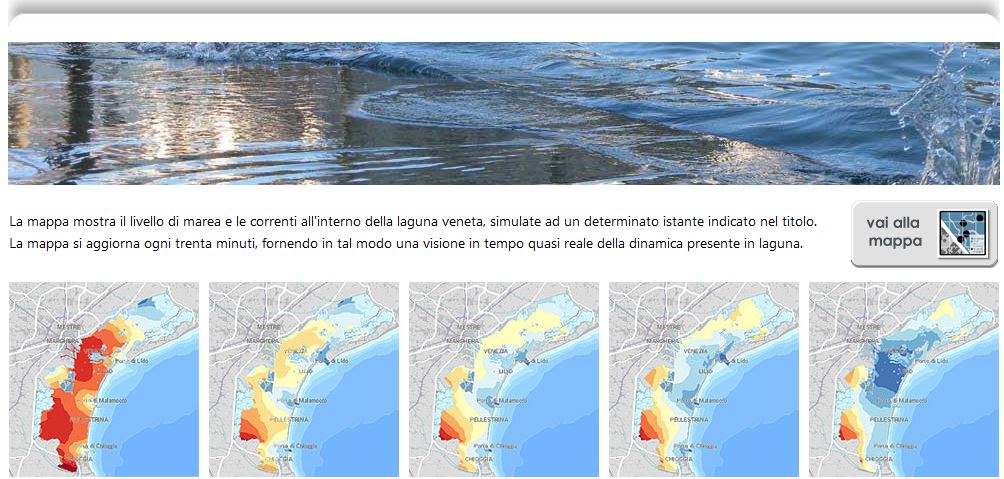
Lagoon atlas – Venice
The Atlas of the lagoon is a web portal which allows access to environmental geographical data about the lagoon of Venice produced by a multitude of public bodies.
Purpose of application
The Atlas of the lagoon is a web portal which allows access to environmental geographical data about the lagoon of Venice produced by a multitude of public bodies.
Geographic extent
Although the lagoon is the area of main interest for the Atlas, environmental data relative to its catchments basin and coastal waters are also included.
Target audience
The key objective of the Atlas is to bring together and organise the information held by separate data producer bodies, so that a variety of users (citizens, professionals, and various institutions) could refer to a single, shared information base.
Data included (general categories)
Number of data sets: approximately two hundreds (every month new datasets are added, especially through WMS protocols).
Information on:
- Base Maps e.g.: main morphological elements, imageries from several years, national and regional topography;
- Biosphere e.g.: habitat of the lagoon, coastal vegetation and habitats, distribution of seagrasses in the lagoon of Venice, fish farms, survey of ecological status of small islands, diffusion of invasive macroalgae;
- Atmosphere climate (maps of air temperature, rainfall and winds in the lagoon and its catchment areas)
- Hydrosphere e.g.: tides and waves; model of temperature, salinity of the lagoon of Venice
- Lithosphere e.g. depth of the lagoon in the years, sedimentology, etc.
- Protected areas (Natura 2000 areas, RAMSAR, IBA, etc.); boat speed limits
- Anthroposphere nature and historic routes, historical military fortifications, public transport lines in the lagoon; pollutant emissions from major industrial plants (from the EEA database EPRTR)
- Special projects georeferenced photographs taken by astronauts from the International
- Space Station; maps of biogenic reefs off the coast of Venice; morphological evolution of the Lagoon.
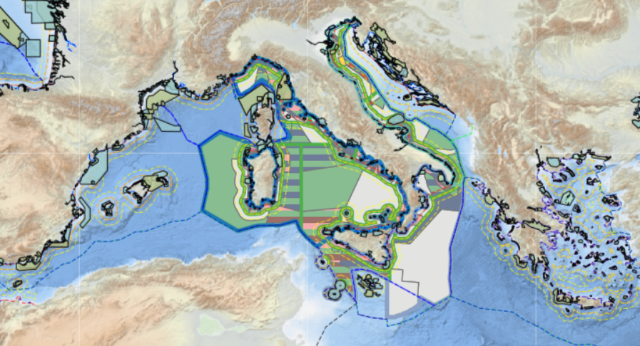
Tools4MSP Geoplatform
The Tools4MSP Geoplatform is a collaborative web-based tool for the co-production, management, and sharing of information resources and scientific knowledge related to coastal and marine areas, with the aim, in particular, of supporting Maritime Spatial Planning (MSP)
Aspects / Objectives
The main objectives of the Tools4MSP Geoplatform are:
- Collecting and organizing existing data and metadata useful for the implementation of the MSP processes;
- Allowing the discovery, access and re-use of such data;
- Enabling the creation and sharing of high-level information contents (interactive maps, dashboards, geostories) for ‘sotrytelling’ to support decision-making processes and environmental sustainability challenges;
- Providing an operational set of geospatially-enabled web-tools (Cumulative Effects Assessment, Maritime Use Conflict Analysis, Marine Ecosystem Services Threat Analysis) that can assist environmental management strategies;
- Promoting the open access to information and tools using standard open licenses;
- Reaching an effective interoperability using standard services (eg. OGC) to connect data from external projects and to provide data to different stakeholders.
Geographic context
The Geoplatform is mainly used in the Adriatic-Ionian and Mediterranean seas, however its functionalities are also applicable in other marine areas.
Contacts:
Related projects
The original version was developed in the context of the ADRIPLAN Project (2013-2015), has been consolidated within the Italian RITMARE Flagship Project (2016-2018), SUPREME (2017-2018), Pharos4MSA (2018-2019), PORTODIMARE (2018-2020) and is being further developed as part of AZA-Sardegna (2020-2023), BRIDGE-BS (2021-2025), MSP4BIO (2022-2025) and ReMAP (2022-2025)
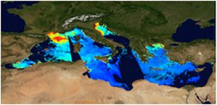
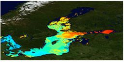
ISMAR Contribution to Copernicus Marine Service
Ocean Color Thematic Assembly Centre (OCTAC) of which ISMAR RM is workpackage leader contributes daily sea color data, SST derived from satellite. In addition GOS provides observations of plankton, SST and Multi Observation TAC radiance emergent optical properties for the Baltic, Black and Mediterranean seas.
The GOS (Global Ocean Satellite monitoring and marine ecosystem study group, also present in the ISMAR detached branch in Naples) of the Institute of Marine Sciences based in Rome contributes to the implementation of an integrated observational system capable of providing the necessary information for the study of ocean processes (physical, biogeochemical) and meeting the needs of an audience of institutional users, national and regional services and ordinary citizens. In particular, it contributes both to the European Commission’s Copernicus Marine Environment Monitoring System (CMEMS) program as prime contractor for: Ocean Color Thematic Assembly Centre (OC TAC), Sea Surface Temperature TAC (SSTTAC) and Dissemination Unit (DS) for the entire CMEMS, to the Multi Observation TAC (MOBTAC) and to the Copernicus Climate Change Service (C3S) as a partner. ISMAR provides the Marine Copernicus program with regional and global satellite products on the marine areas listed below:
- Baltic Sea
- Black Sea
- Mediterranean Sea
- Global Ocean
Contact for further information :
Archive of Adriatic Studies
The Archives of Adriatic Studies ASA is ISMAR’s repository for the consultation of books, papers, documents and scientific collections dedicated to the Venice Lagoon, the Adriatic and the sea in general, from the historical site of the Canonica complex in Venice. The digital and open access archive collects the historical holdings of the Research Institutes that have been based here since 1932: from the Royal Italian Thalassographic Committee to the Institute of Adriatic Studies, from the Maritime Fisheries Observatory to the Institute of Biology of the Sea and the Institute for the Study of the Dynamics of Large Masses, until the merger in 2003 into the Institute of Marine Sciences, which today has its headquarters at the Venice Arsenal. ASA, which is under continuous development thanks to collaboration with IRCrES CNR in Turin, also includes Algarium Veneticum, an algological herbarium that originates from the collection collected between 1941 and 1950 by Michelangelo Minio, Nicolò Spada and Giacomo Zolezzi, enriched now by new sampling for the study of marine biodiversity and transitional environments.
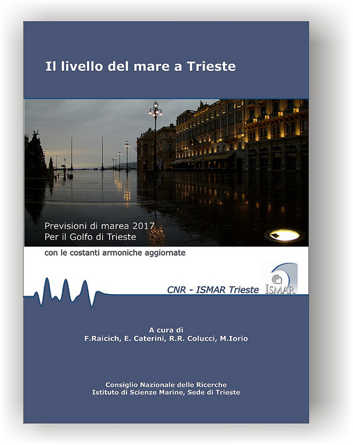
Trieste tide forecast bulletin
The ISMAR detached branch of Trieste produces annual astronomical tide forecasts for the port of Trieste as part of its scientific collaboration with the Alpine-Adriatic Meteorological Society (SMA-A). The forecasts can be downloaded at the link below.
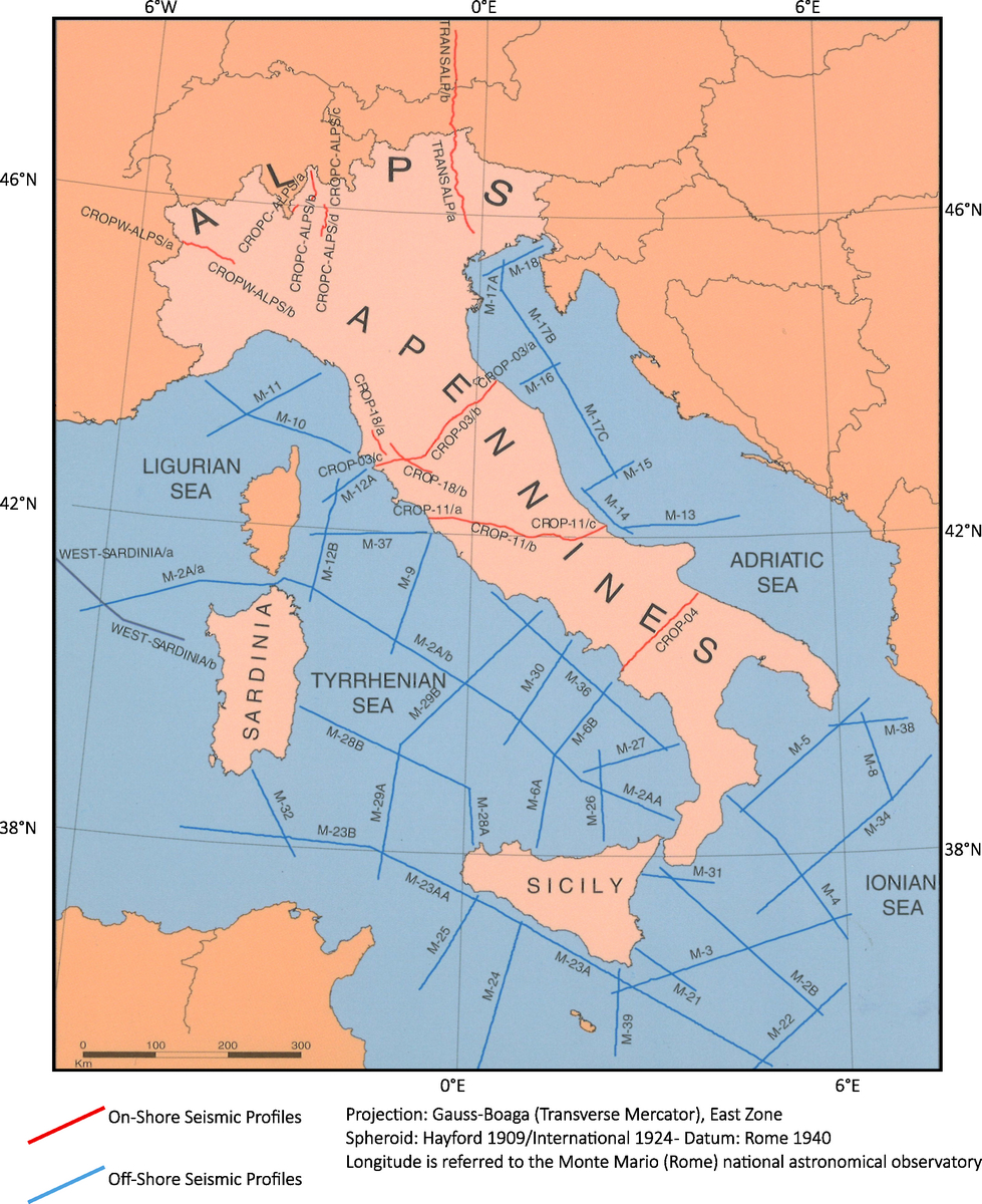
The CROP database
The CROP project (CROsta Profonda) is the Italian Deep Sounding Research Program that, aims to:
- Understand the basic geodynamic processes that have shaped the current configuration of the Italian territory;
- Define and prevent geological risk;
- Explore energy resources such as hydrocarbons and geothermal energy.
The CROP Project was established through a collaboration between CNR, ENI, and ENEL. Two agreements were signed between these organizations in the period from 1989 to 1999, which co-financed the acquisition, processing, and interpretation of approximately 10,000 kilometers of multichannel seismic reflection lines both on land and at sea.
The CROP Database was established by the co-financing entities to ensure data readability, protect magnetic tapes and paper documentation from accidental events, and manage data dissemination in accordance with established regulations. Since 2001, CNR-ISMAR Bologna has been the managing entity, and over the years, they have been responsible for the recovery and cataloging of paper documentation, recovery and standardization of positioning data, recovery and cataloging of magnetic tapes containing the original digital data, reading of magnetic media, data archiving on disk spaces with periodic backups, and the creation of a website (www.crop.cnr.it) for metadata consultation and distribution of digital data to both academic and industrial sectors.
For information on the data, usage guidelines, and inquiries, please refer to the website:
Or contact: