
What is the reason for high water?
High water in Venice is a well-studied phenomenon. Its causes can be divided into different contributions: one is the astronomical tide, one is geological, one meteorological, and one has to do with climate change. The easiest contribution to forecast is the astronomical one. The influence of the moon and the sun create the tides which can be determined with high precision (less than a centimeter) for tens of years in advance. The spring tide, the one which highest contribution, is oscillating between +- 50 cm.
Geology contributes in two ways to high water. The first is subsidence, a slow process that, due to the sedimentary nature of the Po flat, is compacting the soil. This phenomenon is well-studied and stable in time, with values of about 1.4 mm/year. The second contribution is anthropic, caused by men, who extracted in the years 1930-1960 groundwater from below Venice. This water extraction has lowered the Venetian soil by 12 cm.
A contribution to high water difficult to forecast is the meteorological one. This contribution can be divided in a part due to the atmospheric pressure and one due to the wind. The atmospheric pressure changes the water level by 1 cm for every millibar of pressure change. This means that, if Venice is influenced by a low pressure system, the average water level is higher. Pressure can vary quite quickly with the passage of a cyclone, but during a situation of a planetary low pressure system the mean sea level can be high for a long time. This is exactly what happened on November 2019, when throughout the whole month the mean sea level was increased by 30 cm. The wind contribution is easy to understand: with Sirocco winds from the south-east, the wind pushes the water northward where it accumulates just in front of the lagoon and then enters the lagoon through the inlets, creating the phenomenon of high water in Venice. The wind contribution is the most important one, even if it is quite complicated to quantify.
Other two contributions have to be considered. The first one is due to so called “seiches”, a phenomenon that shows up when, after a strong Sirocco wind, the wind stops blowing and the Adriatic basin starts to oscillate. These oscillations can go on for days, even if they rate of damping is 15 % at every oscillation. The principal oscillation has a frequency of 23 hours, very close to the diurnal component of the astronomic tide, which is about 24 hours.
Finally, there is the slow, nearly imperceptible contribution of the global sea level rise due to climate change. This contribution is estimated to be around 3 mm/year, but in the future it is going to accelerate. In the worst case scenario, at the end of the century the rate will be 8 mm/year.
How to predict high water
The prediction of high water is carried outthrough numerical models. Such models can be statistical or deterministic. Thestatistical models are based on the calibration of different parameters, usinglong data sets of variables related to the sea level to be predicted. Thesevariables can include sea level in some locations, but also atmosphericpressure or wind.
Deterministic methods are based instead onsolving the equations of motion of fluids applied to a basin, the MediterraneanSea in this case. The equations are solved through numerical discretization andthe use of powerful calculators. It is necessary to prescribe”boundary” conditions, which consist of wind and pressure data on theconsidered area, for the duration of the simulation. Marine circulation istherefore simulated, including sea level, which is influenced by the action ofwind and atmospheric pressure. These are the two factors that most determinehigh water in Venice. The third fundamental factor is the astronomical tides,which add to the meteorological contribution. However, astronomical tides canbe predicted with good precision for months or years as they depend on theperiodic motions of the sun and the moon. It should also be remembered thatrain has practically no effect on the sea level since neither the Venetianlagoon nor the Adriatic Sea are closed basins.
The CNR forecasting systems
Over the years, ISMAR Venice has developed several numerical models used by different institutions (Municipality of Venice and the Institute for Environmental Protection and Research) for the prediction of the sea level in Venice. Furthermore, some modelling tools are implemented directly at the CNR for research purposes and for testing new developments. Among these, it is worth mentioning KASSANDRA, an oceanographic forecasting system for the Mediterranean and Black seas, born from the collaboration of 3 institutes of the Earth and Environment Department of the CNR (ISMAR, ISAC and IAS). It consists in a 3D finite element hydrodynamic model (SHYFEM), including a tidal model, in a third generation finite element spectral wave model (WWMII), fully coupled to the hydrodynamic model and using as input surface data obtained from a suite of meteorological models provided by CNR-ISAC. The system therefore considers several interactions among wave, surge and tide such as the wave contribution to the total water level by means of wave setup, the influence of tide and surge on the water depth, the depth and current refraction of waves by surge water level and currents.
Simulation of water circulation and of the principal physical processes affecting coastal areas requires the use of both numerical models at high spatial and temporal resolution and downscaling techniques capable of reproducing mass exchange between the coastal area and the open sea (coastal-offshore interactions). This goal has been achieved through the implementation of numerical models based on a unique unstructured grid able to describe processes at different spatial scales. The finite element method permitted to follow the details of bathymetry and morphology in the coastal zone, describing the areas of special interest with higher resolution. The numerical simulation system provides daily forecasts, to maximum 4 days each, for the Mediterranean and Black seas at steps of 3 hours for the total water level (tide + surge + wave set-up), surface currents and significant wave height. The operational forecasts are available at www.ismar.cnr.it/kassandra.
Another important initiative is the development, within the Interreg I-STORMS project, of an IT tool for managing coastal risks due to sea storm. The integrated web system (IWS) is a combination of a common data system for sharing ocean observations and forecasts, a multi-model ensemble system, a geoportal, and interactive geo-visualisation tools to make results available to the general public. IWS was designed to specifically store, visualize and share historical and real-time (or near-real-time) time series of observations from fixed-point sensor networks and outputs from existing operational forecast models. The multi-model ensemble was developed to combine the outcomes of existing ocean and wave forecasting systems, helping with improving the forecast accuracy and reliability by adding indications on the forecast uncertainty. All numerical model results are interpolated on a common regular latitude-longitude grid covering the Adriatic–Ionian macro-region with a resolution 2 km. TMES produces results in terms of the ensemble mean and standard deviation, accounting for a measure of the forecast uncertainty. Monitoring networks’ time series and forecast model outputs are operationally available at https://iws.seastorms.eu/ and http://www.seastorms.eu/.
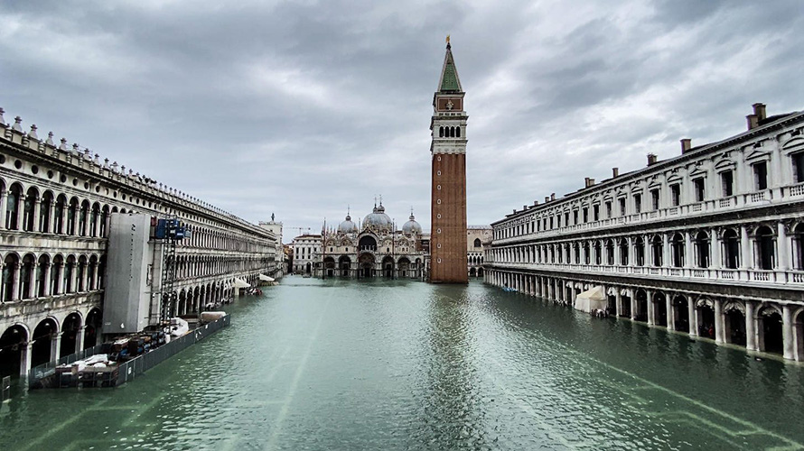
Examples of high water in the past
The event of the 4th of November 1966
The event of 4 November 1966, left in the Venetians’ memory as “aqua granda” (literally large water, i.e., the high flood), was exceptional from various points of view. The meteorological storm affected violently the whole northern part of Italy, leading also to the dramatic Florence flooding and to a devastation (floodings, landslides) in the mountain area. At the time the meteorological forecasts were still approximate, and people had no perception of what was about to come. The nominal level of water in Venice was 1.94 m above the reference 0, in practice 1.2 m in St. Mark square. However, this is only an estimate. Higher for more than half a meter with respect to what previously happened, the water level was higher than what was measurable by the tide gauges of the time. The official 1.94 figure was derived from the oil mark left on the walls of the town after the flood, oil pushed out from the flooded ground-floor oil tanks. The electrical distribution centers were all flooded and in Venice we were without electricity for three days. The last 200 m of the three harbors jetties were literally wiped out. Venice and all the ground-floor houses plus all the shops suffered almost complete damage.
Together with the normal tidal cycle, the water level in Venice remained high, above 1.30 m, for more than 30 hours, all this under heavy rain and violent Sirocco winds. This notwithstanding, a posteriori we can say we were also lucky because the peak of the flooding due to wind was almost coincident with the trough of the astronomical tide. Had everything happened 3 or 4 hours in advance, the maximum sea level would have been 34 cm higher.
How does the 1966 event compare versus the more recent ones, in particular the 12 November 2019, with 1.89 m flooding level? Only 5 cm less? No, the actual difference is much higher because in these 54 years Venice has been sinking, the sea level has been growing, and today the 1966 1.94 m would correspond to at least 2.10 m. With the right (most unfavorable) tidal phase we would have been close to 2.50 m. These once unthinkable figures are today a real possibility. We must also say that the present meteorological, tidal and wave forecasts are highly reliable, also several days in advance. This was indeed the case for also the two big floods, 2018 and 2019, also described on this website. It is also remarkable that, using the present modelling and computer tools, and using only the data of the time, we have been able to show that the 1966 “aqua granda” would now be forecast up to almost six days in advance.
The Vaia storm – 29th of October 2018
October 29 was a very different event from several points of view. The storm, named Vaia, affected the whole northern Italy, the Ligurian and Adriatic Seas, and the mountains with the devastating wind that in several part of Eastern Alps destroyed large part of the local forests. In the morning of 29 a classical Sirocco situation showed a drastic intensification for the so-called explosive development south of Sardinia of a pressure minimum that moved rapidly to North towards the Ligurian Sea. The minimum landed west of Genoa around 18 UTC. The development was defined as “explosive” because its minimum was deepening at an extremely high rate, more than one hPa/h (hecto-Pascal, practically the old millibar). This led to heavy rains on the Ligurian coasts, violent winds first from South-East (Sirocco), then from South-West (a Libeccio derived from the Mistral in the Gulf of Lion), and leading to high destructive waves both East and West of Genoa. On the Adriatic Sea a strong Sirocco led to high waves in its northern part, particularly in front of Venice. At the ISMAR oceanographic tower, located 15 km off the coast on 16 m depth, measured and modeled significant wave heights were up to 6 m, single values up to 11-12 m.
The strong Sirocco wind led to a sustained sea level raising in front of Venice and in the lagoon. A never seen before flooding level, even higher than the famous 4 November 1966, was avoided only because, by mere chance, the maximum surge due to wind happened during the astronomical tide trough. Therefore, the overall maximum was high, but not dramatic. However, this luck for Venice was also the reason of the Eastern Alps disaster. The strong, cold and energetic west-south-west wind that was blowing on the Ligurian Sea, reaching the Apennines range, bypassed it at once precipitating on the Adriatic Sea (end of Sirocco) and on northern Italy. However, this wind squeezed the Sirocco flow against the Eastern Alps, forcing it to pass through a much narrower zone, hence much enhancing its speed. The result were the almost, and also more than, 200 km/h wind speed recorded at various locations, and the flatting of large part of the Dolomites and Carnia forests. The fury was short, 2 or 3 hours, well forecast and announced (no fatality), but disastrous with still visible consequences.
The event of the 12th of November 2019
On the 12th November 2019, an exceptionally high sea level event occurred in Venice, second only to the event that occurred on November 4th, 1966. Although an exceptional high tide (>140 cm) was predicted by the numerical models in use, during the evening, sudden gusts of wind at more than 100 km per hour generated a further local intensification of this phenomenon. On November 12th, 2019, a deep low pressure system was present over the central-southern Tyrrhenian Sea, which generated strong Scirocco (south-easterly) winds along the main axis of the Adriatic Sea, while, at the same time, Bora (north-easterly) winds blew over the Northern Adriatic. In addition to this “large scale” configuration, the northern Adriatic was affected by the passage of a secondary cyclonic vortex rotating and moving rapidly, which quickly deepened (i.e. intensified) causing very strong winds (70 km/h on average and 110 km/h gusts). The maximum sea level value of 189 cm was recorded in Venice at “Punta della Salute” and occurred at 22:50 with a delay of about an hour compared to the peak of 182 cm, recorded offshore by the Platform “Acqua Alta”. Several factors made this event so exceptional:
- il picco della marea astronomica di sizigia;
- il livello medio insolitamente elevato del mare in Adriatico;
- il forte vento di Scirocco lungo il bacino Adriatico;
- il passaggio di un intenso minimo depressionario sul bacino nord Adriatico e laguna di Venezia.
The event of 12 November must however be framed within an exceptional month of November, in which particular meteorological conditions determined several events of high waters in Venice. Contrary to what happened in the two extreme events described above, on 12 November 2019 the peak of the sea storm overlapped the astronomical tide peak and a high average sea level in the North Adriatic, thus bringing a less intense storm compared to 1966 and 2018 to reach exceptional level values in Venice.
What the future brings: climate change
The global sea level is now rising faster, in particular with the contribution of melting glaciers and ice sheets. Sea level rise measured by tide gauges and altimetry increased from 1.4 mm/year in the period 1901-1990 to 3.6 mm/year in the period 2006-2015. On the other hand, in the Mediterranean Sea, the sea level rose with lower intensity with respect to global values; significant variability at regional scale should in fact be taken into account. Increase in sea level rise is also expected to continue according to climate scenarios: by 2050, business as usual scenarios predict 32 ± 8 cm (IPCC). It should be noted that the time horizon to 2050 is relatively close and uncertainties in climate scenarios are lower with respect to longer time horizons as, e.g., to 2100. Sea level rise, superimposed to the effects of severe disturbances, will make storm surge events, with otherwise very long return periods in the recent past, more frequent. This is actually happening in Venice, where in the last 50 years, on one side, the number of major storm surge events increased relentlessly, while on the other side, unfavorable meteorological conditions did not really increase in frequency. An illustrative example is what happened in fall 2019. The synoptic conditions, leading to Sirocco winds (south-easterlies) not particularly extreme, caused instead a record breaking number of successive events just because of an anomalously high monthly sea level in the Adriatic Sea. While the high sea level in November 2019 was temporarily a consequence of persistent low pressure conditions, in 2050 the sea level rise will make such situations a standard, i.e., when weak sirocco events will be enough to generate significant flooding. Continuous improvements in knowledge and forecasting skills will therefore become even more a valuable ally in mitigating the future impacts of the acqua alta phenomenon.
Pubblication
M. Bajo, G. Umgiesser. Storm surge forecast through a combination of dynamic and neural network models, Ocean Modelling, Volume 33, Issues 1–2, 2010, Pages 1-9, ISSN 1463-5003, https://doi.org/10.1016/j.ocemod.2009.12.007.
M. Bajo, L. Zampato, G. Umgiesser, A. Cucco, P. Canestrelli, A finite element operational model for storm surge prediction in Venice, Estuarine, Coastal and Shelf Science, Volume 75, Issues 1–2, 2007, Pages 236-249, ISSN 0272-7714, https://doi.org/10.1016/j.ecss.2007.02.025.
Cavaleri, L., M. Bajo, F. Barbariol, M. Bastianini, A. Benetazzo, L. Bertotti, J. Chiggiato, S. Davolio, C. Ferrarin, L. Magnusson, A. Papa, P. Pezzutto, A. Pomaro, and G. Umgiesser (2019), The October 29, 2018 storm in Northern Italy – an exceptional event and its modeling, Prog. Oceanogr., 178, 102,178, doi:10.1016/j.pocean.2019.102178
Cavaleri, L., M. Bajo, F. Barbariol, M. Bastianini, A. Benetazzo, L. Bertotti, J. Chiggiato, C. Ferrarin, F. Trincardi, and G. Umgiesser (2020), The 2019 flooding of Venice and its implications for future predictions, Oceanography, 33(1), 42–49, doi:10.5670/oceanog.2020.105
Ferrarin, C., A. Roland, M. Bajo, G. Umgiesser, A. Cucco, S. Davolio, A. Buzzi, P. Malguzzi, and O. Drofa (2013c), Tide-surge-wave modelling and forecasting in the Mediterranean Sea with focus on the Italian coast, Ocean Model., 61, 38–48, doi:10.1016/j.ocemod.2012.10.003
Ferrarin, C., A. Valentini, M. Vodopivec, D. Klaric, G. Massaro, M. Bajo, F. De Pascalis, A. Fadini, M. Ghezzo, S. Menegon, L. Bressan, S. Unguendoli, A. Fettich, J. Jerman, M. Liˇcer, L. Fustar, A. Papa, and E. Carraro (2020), Integrated sea storm management strategy: the 29 October 2018 event in the Adriatic Sea, Nat. Hazards Earth Syst. Sci., 20(1), 73–93, doi: 10.5194/nhess-20-73-2020
Trincardi, F., Barbanti, A., Bastianini, M., Benetazzo, A., Cavaleri, L., Chiggiato, J., Papa, A., Pomaro, A., Sclavo, M., Tosi, L. & Umgiesser, G. (2016). What time taught us for the future: The 1966 Flooding of Venice. Oceanography, 29(4), 178-186. DOI:10.5670/oceanog.2016.87