
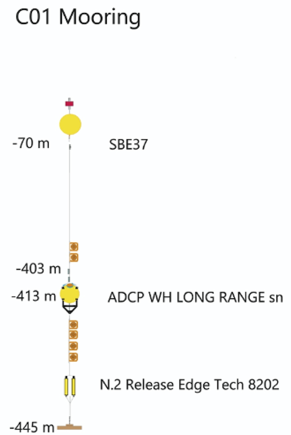
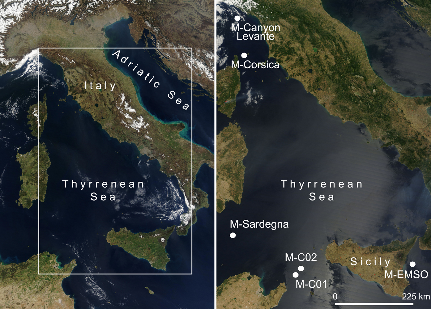
Sicily Channel 1 (C01)
Location: 37.380° N, 11.591° E
WMO code: 6101021
Deep submarine multidisciplinary station managed by ISMAR, positioned between the Sicily and Tunisia coast, at about 450 m deep, off the wide continental shelf at the western sill of Sicily Strait. It is dedicated to long term monitoring of surface and intermediate circulation and water exchanges between the eastern and western Mediterranean basins.
It has been active since 1993, initially equipped with traditional current meters, actually provides current vertical profiles throughout the water column with ADCP. At the bottom depth, it is equipped by high precision CTD probes to provide continuous measurement over time of water masses thermohaline properties. The site is part of the CIESM Hydrochanges project and participated in the JERICO/JERICO-NEXT transnational access project (EU FP7 G.A. n. 262584 e EU H2020 G.A. n. 654410).
The station has been equipped with sensors for multiparametric measurements (temperature, salinity, oxygen, turbidity and pCO2), through the structural funds of the PAC project. Furthermore, in order to allow the transfer of data in real time, a process of transformation into inductive mooring was tested.
Publications:
Astraldi, M., Gasparini, G.P., Sparnocchia, S., Moretti, M. and Sansone, E.: The characteristics of the water masses and the water transport in the Sicily Strait at long time scales. In Dynamics of Mediterranean Straits and Channels, F. Briand (ed.), Bulletin del l’Institut Océanographique, Monaco, no spécial 17, CIESM Science Series no 2, 95-115, 1996.
Gasparini, G.P., Smeed, D.A., Alderson, S., Sparnocchia, S., Vetrano, A. and Mazzola, S.: Tidal and subtidal currents in the Strait of Sicily, J. Geophys. Res., 109, C02011, doi:10.1029/2003JC002011, 2004.
Gasparini, G.P., Schroeder, K. and Sparnocchia, S.: Straits and Channels as key regions of an integrated marine observatory of the Mediterranean: our experience on their long-term monitoring. In Towards an integrated system of Mediterranean marine observatories, F. Briand (Ed.), CIESM Workshop Monographs, No 34, 75-79, 2008.
Schroeder, K. et al.: Long-term monitoring programme of the hydrological variability in the Mediterranean Sea: a first overview of the HYDROCHANGES network. Ocean Sci., 9, 301–324, 2013, doi:10.5194/os-9-301-2013.
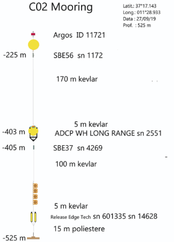
Sicily Channel 2 (C02)
Location: 37.285° N, 11.5° E
WMO code: 6101022
Deep submarine multidisciplinary station managed by ISMAR, positioned between the Sicily and Tunisia coast, at 530 m deep, about 20 nautical miles west of the site C01 at the western sill of Sicily Strait. It is dedicated to long term monitoring of surface and intermediate circulation and water exchanges between the eastern and western Mediterranean basins. It has been active since 1993, initially equipped with traditional current meters, actually provides current vertical profiles throughout the water column with ADCP. At the bottom depth, it is equipped by high precision CTD probes to provide continuous measurement over time of water masses thermohaline properties.
The site is part of the CIESM Hydrochanges project and participated in the JERICO/JERICO-NEXT transnational access project (EU FP7 G.A. n. 262584 e EU H2020 G.A. n. 654410).
Publications:
Astraldi, M., Gasparini, G.P., Sparnocchia, S., Moretti, M. and Sansone, E.: The characteristics of the water masses and the water transport in the Sicily Strait at long time scales. In Dynamics of Mediterranean Straits and Channels, F. Briand (ed.), Bulletin del l’Institut Océanographique, Monaco, no spécial 17, CIESM Science Series no 2, 95-115, 1996.
Gasparini, G.P., Smeed, D.A., Alderson, S., Sparnocchia, S., Vetrano, A. and Mazzola, S.: Tidal and subtidal currents in the Strait of Sicily, J. Geophys. Res., 109, C02011, doi:10.1029/2003JC002011, 2004.
Gasparini, G.P., Schroeder, K. and Sparnocchia, S.: Straits and Channels as key regions of an integrated marine observatory of the Mediterranean: our experience on their long-term monitoring. In Towards an integrated system of Mediterranean marine observatories, F. Briand (Ed.), CIESM Workshop Monographs, No 34, 75-79, 2008.
Schroeder, K. et al.: Long-term monitoring programme of the hydrological variability in the Mediterranean Sea: a first overview of the HYDROCHANGES network. Ocean Sci., 9, 301–324, 2013, doi:10.5194/os-9-301-2013.
Corsica Channel
Location: 43.025 N, 9.6833 E
WMO code: 6101020
Underwater station at about 450 m depth operated by ISMAR, positioned between the island of Capraia and Corsica, at the threshold of the Channel itself. It continuously measures sea currents and thermohaline properties of water masses at predetermined depths, for monitoring surface and intermediate circulation and exchanges between the two adjacent basins (Tyrrhenian Sea and Ligurian Sea).
It has been active since 1985. The site is part of the CIESM Hydrochanges program and participated in the JERICO transnational access program (EU FP7 G.A. No. 262584).
Since 2013, measurements of pCO2 at the 400 m elevation have been initiated under the PERSEUS project (EU FP7 G.A. No. 287600), and in the same year, with national funds from the RITMARE and SSD Fisheries projects, the current meter chain was equipped with a Profiling Buoy System for real-time data transmission (daily frequency). The observed data are transmitted via Iridium antenna via SBD (short burst data).
The Profiling Buoy System consists of two main units: the winch and the profiling buoy, which is equipped with multi-parameter probe (temperature, salinity, oxygen and chlorophyll), Iridium, acoustic communication system and data logger. The system works according to a time table programmed in the internal memory and can be acoustically controlled from ship via Deck Unit, also the sampling table can be changed by satellite communication via email.
Publications:
Astraldi, M. and Manzella, G. M. R.: Some observations on current measurements on the Eastern Ligurian Shelf, Mediterranean Sea, Cont. Shelf Res., 2, 183–193, 1983.
Astraldi, M., Gasparini, G. P., Manzella, G. M. R. and Hopkins, T.: Temporal variability of currents in the eastern Ligurian Sea, J. Geophys. Res., 95(C2), 1515–1522, 1990.
Astraldi, M. and Gasparini, G.P.: The seasonal characteristics of the circulation in the north Mediterranean basin and their relationship with the atmospheric-climatic conditions, J. Geophys. Res., 97 (C6), 9531-9540, 1992.
Astraldi, M., Gasparini, G.P. and Sparnocchia, S.: The Seasonal and Interannual Variability in the Ligurian-Povencal Basin. In Seasonal and Interannual Variability of the Western Mediterranean Sea, P.E. La Violette (Ed.), Coastal and Estuarine Studies vol. 46, AGU, 93-113, 1994.
EURO MODEL Group: Progress from 1989 to 1992 in understanding the circulation of the Western Mediterranean sea. Oceanologica Acta, 18(2), 255-271, 1995.
Vignudelli, S., Gasparini, GP., Astraldi, M. and Schiano, M.E.: A possible influence of the North Atlantic Oscillation on the circulation of the Western Mediterranean Sea, Geophys. Res. Letters, 26(5), 623-626,1999.
Vignudelli, S., Cipollini, P., Astraldi, M., Gasparini, G.P. and Manzella, G.: Integrated use of altimeter and in situ data for understanding the water exchanges between the Tyrrhenian and Ligurian Seas, J. Geophys. Res., 105(C8), 19649–19663, 2000.
Gasparini, G.P., Schroeder, K. and Sparnocchia, S.: Straits and Channels as key regions of an integrated marine observatory of the Mediterranean: our experience on their long-term monitoring. In Towards an integrated system of Mediterranean marine observatories, F. Briand (Ed.), CIESM Workshop Monographs, No 34, 75-79, 2008.
Schroeder, K. et al.: Long-term monitoring programme of the hydrological variability in the Mediterranean Sea: a first overview of the HYDROCHANGES network. Ocean Sci., 9, 301–324, 2013, doi:10.5194/os-9-301-2013.
Aracri, S., Borghini, M., Canesso, D., Chiggiato, J., Durante, S., Schroeder, K., Sparnocchia, S., Vetrano, A., Honda, T., Kitawaza, Y., Kawahara, H. and Nakamura, T.: Trials of an autonomous profiling buoy system, J. Oper. Oceanogr., Journal of Operational Oceanography, 9:sup1, 176-184, 2016.
EMSO SN1
Location: 37.5400433 N, 15.397313333 E
WMO code: 6202000
Mooring co-managed with INGV and positioned at the SN1 node of the European Multidisciplinary Seafloor Observatory (EMSO) research infrastructure, 25 km offshore Catania. It complements the EMSO SN1 infrastructure by conducting monitoring in the water column.
Inductive mooring at about 2010 m depth, positioned at the SN1 node of the EMSO (European Multidisciplinary Seafloor Observatory) research infrastructure, 25 km offshore Catania, southeastern Sicily. It complements the EMSO SN1 infrastructure by performing continuous monitoring of temperature, salinity, dissolved oxygen, and turbidity at 4 depth levels (ca 380, 890, 1390, and 1890 m), and CO2 partial pressure and bottom pressure at 1990 m. It is also equipped with acoustic current meters that return current profiles between 0-380 m, 790-890 m and 1290-1390 m. Data collected by the instruments are fed to a control system and data logger (CommTech LISC) installed at the base of the mooring.
The mooring was positioned at 37°32.4026′ N, 15°23.8388′ E, on March 18, 2015. It is currently operating in recording mode without transmission. Soon it will be put in acoustic communication with the junction box of SN1 and data will be accessible from it in real time, via fiber optics.
A profiling system to measure water column properties from 150 m (approximately) depth to the surface was installed at the head of the mooring on March 16, 2016. The system consists of two main units: the winch and the profiling buoy, which is equipped with multi-parameter probe (temperature, salinity, oxygen, turbidity and fluorescence), acoustic communication system, data logger and Iridium antenna for data transmission. The system was programmed to perform an ascent every two days.
The infrastructure was developed with funds from the PAC program “Plan of Action and Cohesion for Convergence Regions, Project PAC01_00044 – EMSO-MedIT, financed under the Line of Intervention “Research and Innovation” – Action “Structural Enhancement” – MIUR Notice D.D. No. 274 of 15/02/2013.
Publications:
S. Sparnocchia, M. Borghini, S. Durante, V. Meccia, A. Giordano and G. Biasini, “From the seafloor to the sea surface: A technical solution for the cabled EMSO-SN1 observatory in the Western Ionian Sea,” OCEANS 2015 – Genova, Genova, Italy, 2015, pp. 1-5, doi: 10.1109/OCEANS-Genova.2015.7271527.
Sardinia Channel
Location: 38.3341 N, 9.33265 E
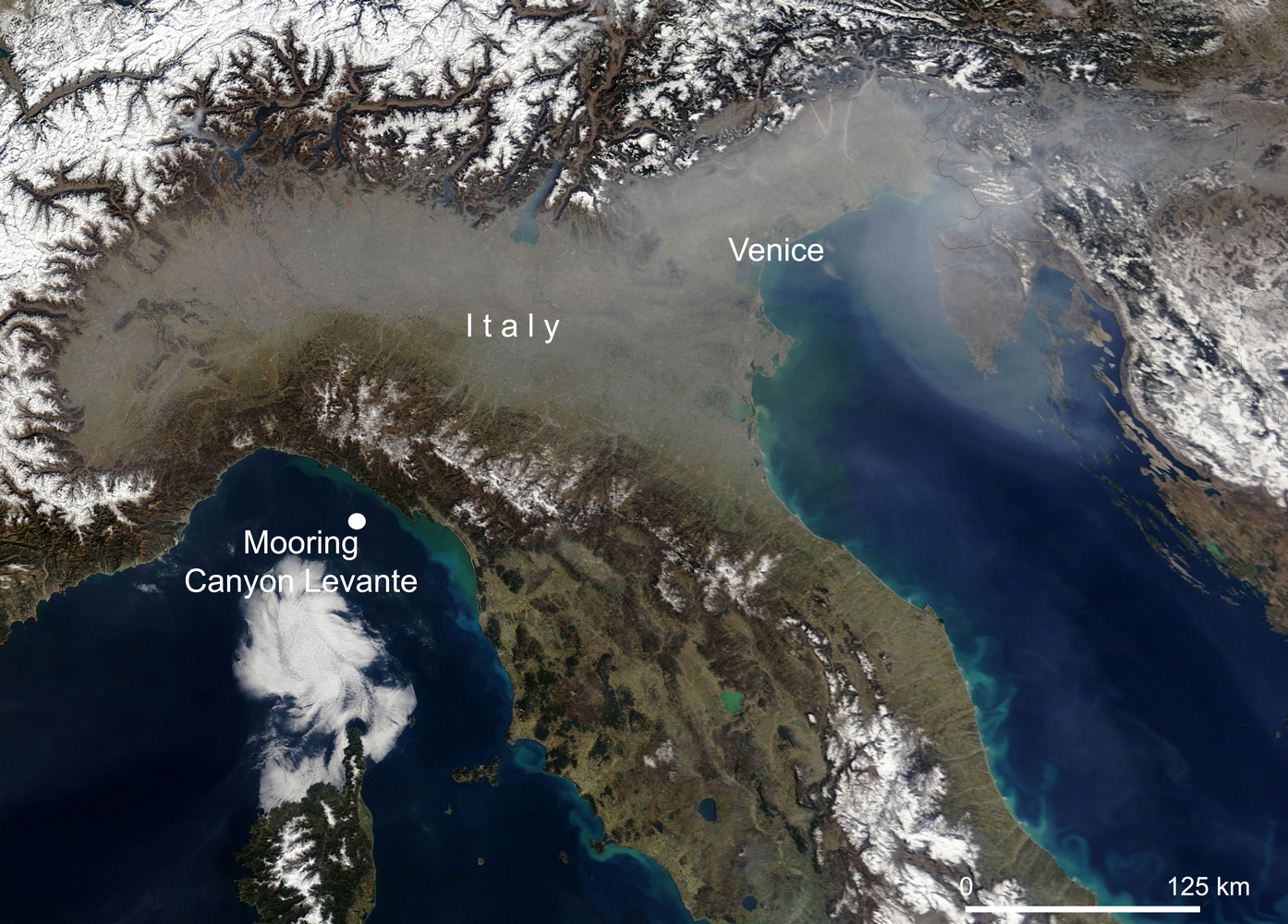
Eastern Canyon
Location: 44.0907167 N, 9.498333333 E
Mooring installed in September 2019 on a 600-m seabed off the Cinque Terre Marine Protected Area.
The station is equipped with a number of instruments for monitoring key marine physical parameters, such as current meters, with sensors for measuring temperature and salinity at three different depths along the water column, as well as traps for sediment sampling.
As of October 2022, the site is equipped with instrumental equipment designed to study the degradation of plastic material in the deep environment.