
Oceanographic modelling
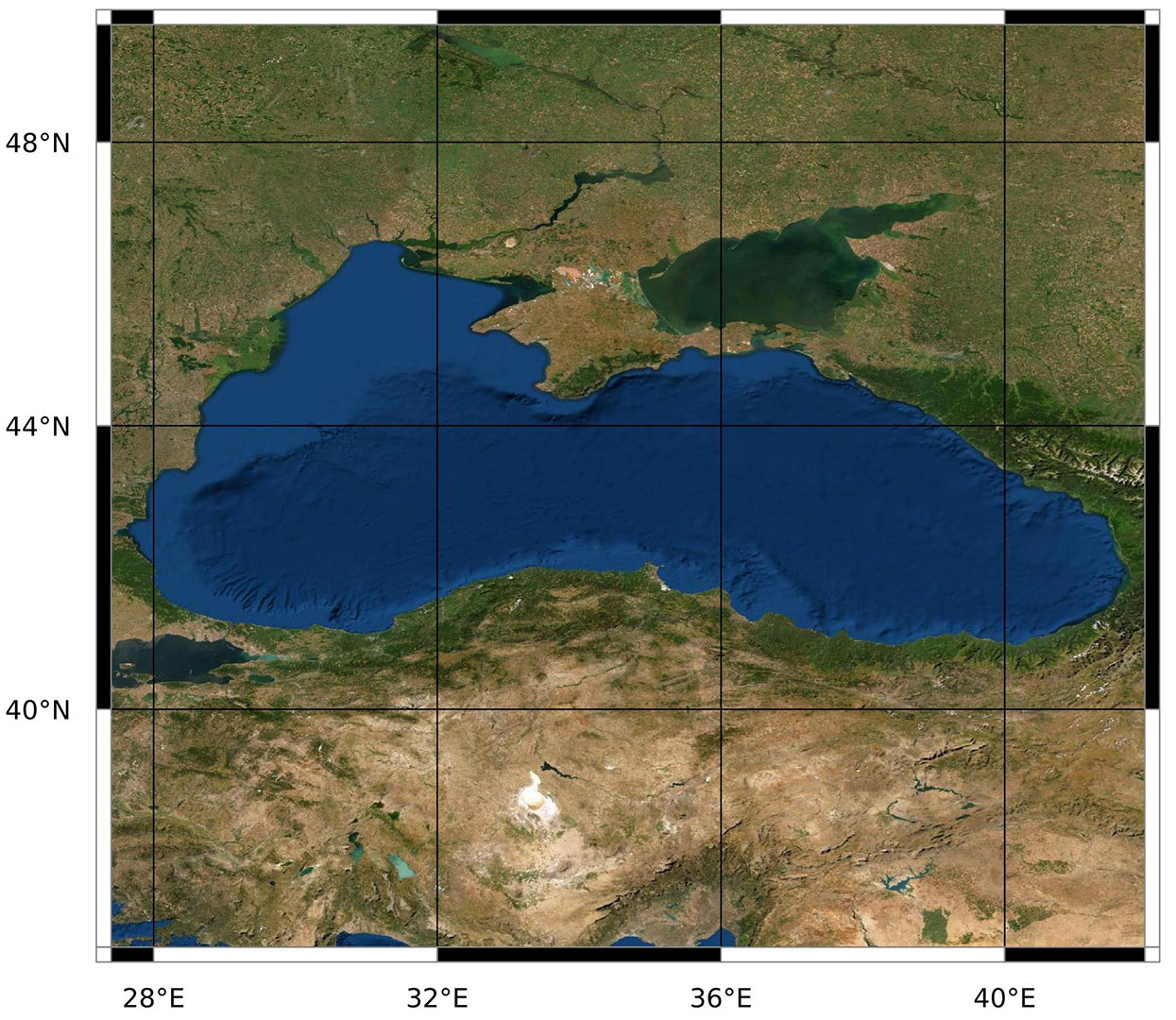
Black Sea
CNR-ISMAR offers the potentiality of the SHYFEM model to integrate the land-sea continuum in prototypes of operative chains, spanning from hydrodynamics, to sediment transport, biogeochemistry and marine litter.
The first CNR-ISMAR modelling implementations in the Black Sea were focussed on the western coast, using the numerical model SHYFEM, created and developed at CNR-ISMAR. The close cooperation with the main scientific institutions of the Black Sea allowed further developments both on operational modelling and process studies. CNR-ISMAR
is presently working on developing integrated models (for process studies on the river-sea interaction, storm surge and waves, coastal hydro- and biogeochemical dynamics, sediment and marine litter transport, through modeling chains from the catchment to the open sea) and prototypes of operational models’ chains to reproduce the land-sea continuum; the modelling effort in the Black Sea contributes to the ambitious concept of SoS (System of Systems) to integrate data from remote sensing, in-situ measurements and models, in order to enrich the future data availability for each national system in the Black Sea.
Bajo M., Ferrarin C., Dinu I., Umgiesser G., Stanica A. M. Bajo, C. Ferrarin, I. Dinu, G. Umgiesser, A. Stanica The water circulation near the Danube Delta and the Romanian coast modelled with finite elements Continental Shelf Research, 78 (2014), pp. 62-74 DOI: 10.1016/j.csr.2014.02.006.
DINU, I., UMGIESSER, G., BAJO, M., PASCALIS, F. D., STĂNICĂ, A., POP, C., DIMITRIU, R., NICHERSU, I., & CONSTANTINESCU, A. (2016). MODELLING OF THE RESPONSE OF THE RAZELM-SINOE LAGOON SYSTEM TO PHYSICAL FORCING.
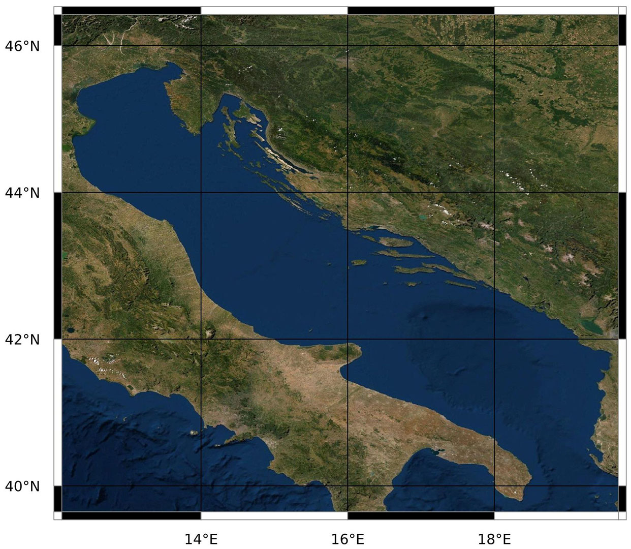
Adriatic Sea
The comprehension, description and forecast of oceanographical and coastal processes of the Adriatic Sea are tackled in ISMAR with the development and implementation of several numerical models covering a broad range of spatial and temporal resolutions.
The Adriatic sea is a subbasin of the Mediterranean Sea which is particularly subject to impacts from human activities and climate changes. Hence, the investigation of its processes and dynamics if fundamental not only from a purely scientific point of view but also for planning and management of the marine environment. ISMAR develops and implements several numerical models to produce forecasts (link) and to study the oceanographical processes such as riverine plumes (for example the the Po River and its Delta), the coastline evolution and morphodynamics, dispersion
patterns for dissolved and particulated (micro and macro plastics) pollutants and the impacts of climate changes. The main models used are the unstructured grid model SHYFEM (directly developed by ISMAR, link) and the Regional Ocean Modelling System (ROMS) and several lagrangian transport models.
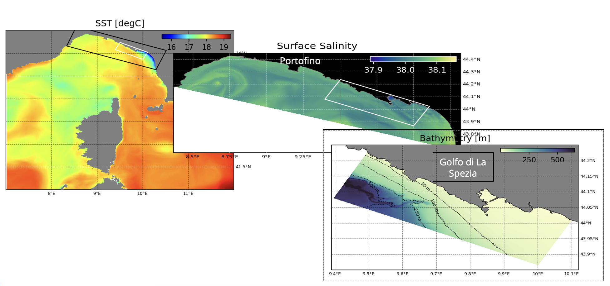
Ligurian Sea (LIME system)
LIME is a chain of hindcast oceanographic models. The chain consists of three models (LIME-ROMS, LIMEgcm and LIME-D3D) of increasing resolution (1.2km, 300m, 50m), covering respectively: the Ligurian and North-Tyrrhenian Seas, the Ligurian coast and the area near the Cinque Terre and La Spezia.
LIME is a chain of oceanographic models that simulates the dynamics of the Ligurian Basin. The chain consists of three models of increasing resolution based on three different hydrodynamical cores. The first is LIME-ROMS, which is based on the hydrodynamic core of ROMS and resolves the dynamics within the Ligurian and the North-Tyrrhenian Seas at a resolution of 1.2 km. LIMEgcm has a resolution of 300m and resolves the dynamics of the Ligurian coast being based on the the MITgcm core. The chain ends with the LIME-D3D model, which simulates the area in front of the Cinque Terre and the port of La Spezia at a resolution of 50m using the Delft3D hydrodynamical core. The modeling chain simulates in hindcast mode. The choice of three different hydrodynamical cores allows the exploitation of the specific characteristics of each model at the selected scale. For example, LIMEgcm can be run in a non-hydrostatic mode to assess the importance of vertical motions in coastal areas. The three models can be used to run Lagrangian simulations for biological or pollutant dispersion applications.
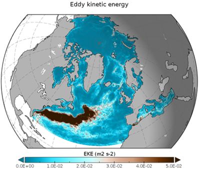
North Atlantic and Arctic
The North Atlantic Ocean circulation patterns and anomalies have fundamental implications on the Mediterranean climate. ISMAR devotes significant efforts to the understanding of the multi-scale inter-connected oceanic circulation in the North Atlantic and Arctic Oceans and the Mediterranean Sea through multi-model simulation activities in the area.
ISMAR has implemented the NEMO ocean model (Nucleus for European Modelling of the Ocean, coupled with the SI3 multi-category sea ice model, over the area covering the North Atlantic and Arctic Oceans, from about 26°N in the Atlantic to the Bering Strait, including the Mediterranean Sea.
The model runs at different spatial resolutions (1/4°, 1/12° and 1/36°) and 75 vertical levels, and it is mainly used to study the impact of mesoscale eddies on the meridional redistribution of heat, the impact of the spatial resolution of numerical models on the population of eddies and on local energy budgets.
Lagrangian modelling (LAgrangian Variational Analysis LAVA)
LAVA is an open-source software for combining different types of oceanographic data (“data fusion or data blending”) that is extremely useful for managing emergencies at sea, such as oil spills and search and rescue operations.
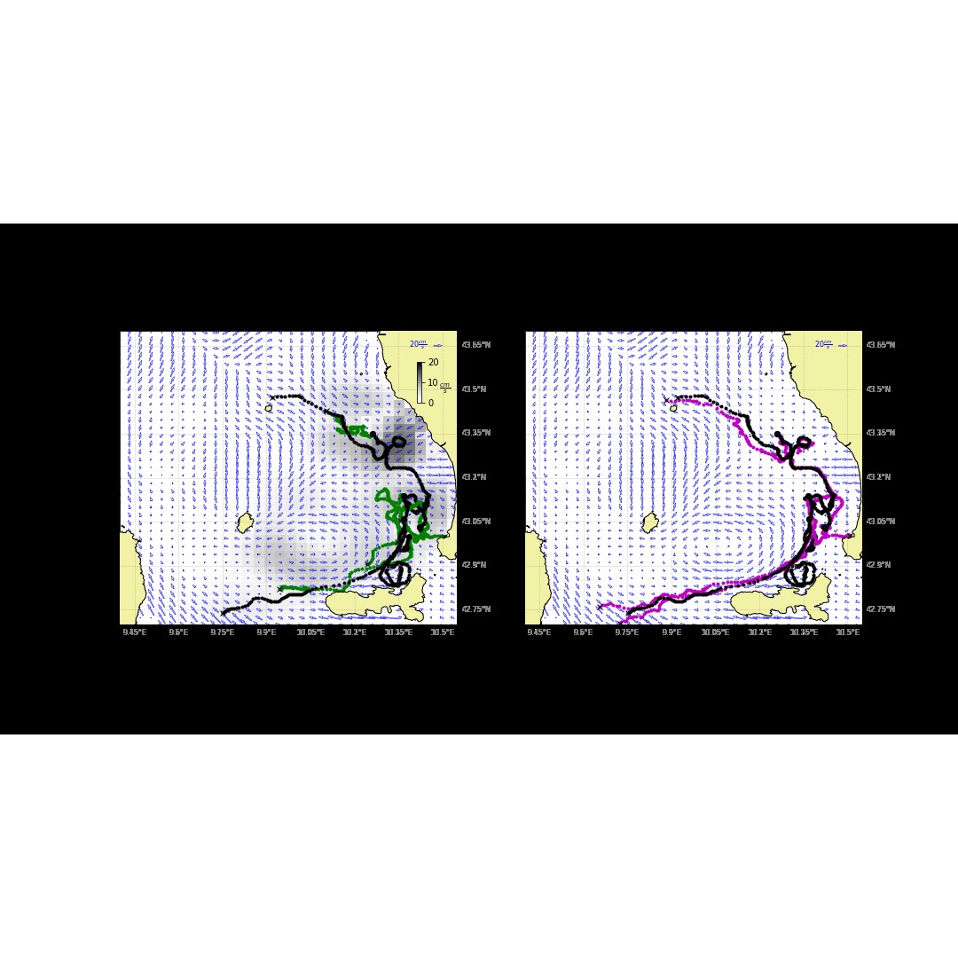
LAVA was developed by CNR-ISMAR together with the Universities of Toulon and Miami. LAVA provides an optimal blending of information on the speed and direction of ocean currents from different types of oceanographic instruments. The approach is Lagrangian and variational, requiring the minimisation of the distance between observed Lagrangian positions and those obtained by numerically integrating an Eulerian field. Figure shows a specific example of applying LAVA software to velocities measured by coastal radars. Integrating the original radar velocity data yields trajectories (in green in the left panel) that diverge from those observed by the drifters (in black). By considering other drifters in the area and applying LAVA, the velocities are corrected locally and this allows the new trajectories (in purple on the right pane;) to be closer to those observed by the drifters. The improvement is important from a practical and operational point of view: the more precise trajectory estimates obtained with LAVA considerably reduce the uncertainty in the radius of operation for both search and rescue and oil spills applications.
Global Ocean
Understanding the global ocean-climate dynamics and changes at different temporal and spatial scales requires advanced numerical models to support process-oriented investigations. Global configurations of the NEMO ocean model are run by ISMAR for climate-oriented investigations.
In order to address fundamental questions about global ocean and climate dynamics and changes at different temporal and spatial scales, state-of-the-science numerical models are needed to support process-oriented investigations.
For such large-scale climate-oriented studies, ISMAR utilizes the NEMO ocean model (Nucleus for European Modelling of the Ocean), coupled with the SI3 multi-category sea-ice model. NEMO is implemented in a global tripolar grid (ORCA) at both eddy-poor (1°) and eddy-permitting (1/4°) horizontal resolutions, and 75 vertical depth levels. These configurations are run over multi-decadal periods to analyze the temporal variations of the global and regional oceanic heat content and thermohaline circulation, to disentangle the effect of different sources of uncertainty (e.g. atmospheric forcing, physics parameterizations, etc.) on the representation of the climate proxies, to formulate stochastic physics schemes that provide a probabilistic representation of the changing climate, and to develop century-long observation-aware reconstructions of the global ocean climate, like for instance with the CIGAR (Cnr Ismar Global historicAl Reanalysis) ensemble ocean reanalysis system.