
Mediterranean Sea (MESMAR coupled model)
ISMAR has developed a regional Earth System Model for the Mediterranean area that includes coupled regional atmospheric and oceanic numerical models and an interactive river runoff scheme. This Earth System Model, called MESMAR (Mediterranean Earth System model at ISMAR), is mainly used for regional long-range predictability studies, coupled data assimilation experiments, and assessment of advanced air-sea flux formulations.
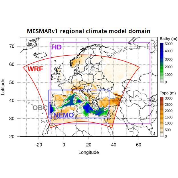
Regional climate modeling is increasingly recognized as a crucial tool for a broad range of scientific investigations and climate services. ISMAR has recently developed a regional Earth System Model for the Mediterranean area, which is made up of several state-of-the-science numerical models: the WRF atmospheric model (Weather Research and Forecasting) coupled with the Noah-MP land surface model, the NEMO ocean model (Nucleus for European Modelling of the Ocean), and the HD (Hydrological Discharge) model for the interactive runoff. Both ocean and hydrological discharge models are implemented at about 7 km of horizontal resolution. The three modeling systems exchange freshwater, heat, and momentum fluxes via the OASIS (OASIS3-MCT) coupler. This regional Earth System Model is run within either long climate simulations or in prediction configuration, for several studies and projects. Its adoption fosters sub-seasonal to seasonal predictability studies, the formulation of new coupled data assimilation algorithms and their verification for selected events, and the evaluation of improvements in the formulation of air-sea flux exchanges.
References:
Storto, A., Hesham Essa, Y., de Toma, V., Anav, A., Sannino, G., Santoleri, R., and Yang, C.: MESMAR v1: A new regional coupled climate model for downscaling, predictability, and data assimilation studies in the Mediterranean region, Geosci. Model Dev. Discuss. [preprint], https://doi.org/10.5194/gmd-2023-77, in review, 2023.